Twenty-two percent of the world's fresh surface water. Most of it unmapped below 600 feet.
The Great Lakes are not lakes in any useful sense of the word. They are inland seas — Superior alone is larger than South Carolina and deep enough to swallow the buildings of Chicago without a trace of them surfacing. The combined shoreline runs to nearly 10,000 miles of beach, cliff, wetland, and river delta. The shipping industry has worked these waters for 200 years and has still not produced a complete understanding of what the depths contain.
The shore country itself — the forests of northern Wisconsin and the Upper Peninsula of Michigan, the farm roads of rural Ohio, the limestone ridges of the Door Peninsula — produces a separate category of land-based encounters that draws researchers from across the region. Wisconsin's Walworth County alone has generated more documented large canid sightings per square mile than any other county in the continental United States. The concentration is not explained by population density, media coverage, or hoax clusters. Something is using those farm roads at night.
Anishinaabe peoples have inhabited this region for over a thousand years and have maintained detailed records — in oral tradition, in birchbark scrolls, and in the pictographs at Agawa Rock on Lake Superior's northern shore — of the entities that share the water and the land. The Agawa Rock paintings, made before European contact, depict Mishipeshu, the Underwater Panther, in detail sufficient to function as a field identification guide. That is a long time to document something that does not exist.
Documented Entities
South Bay Bessie
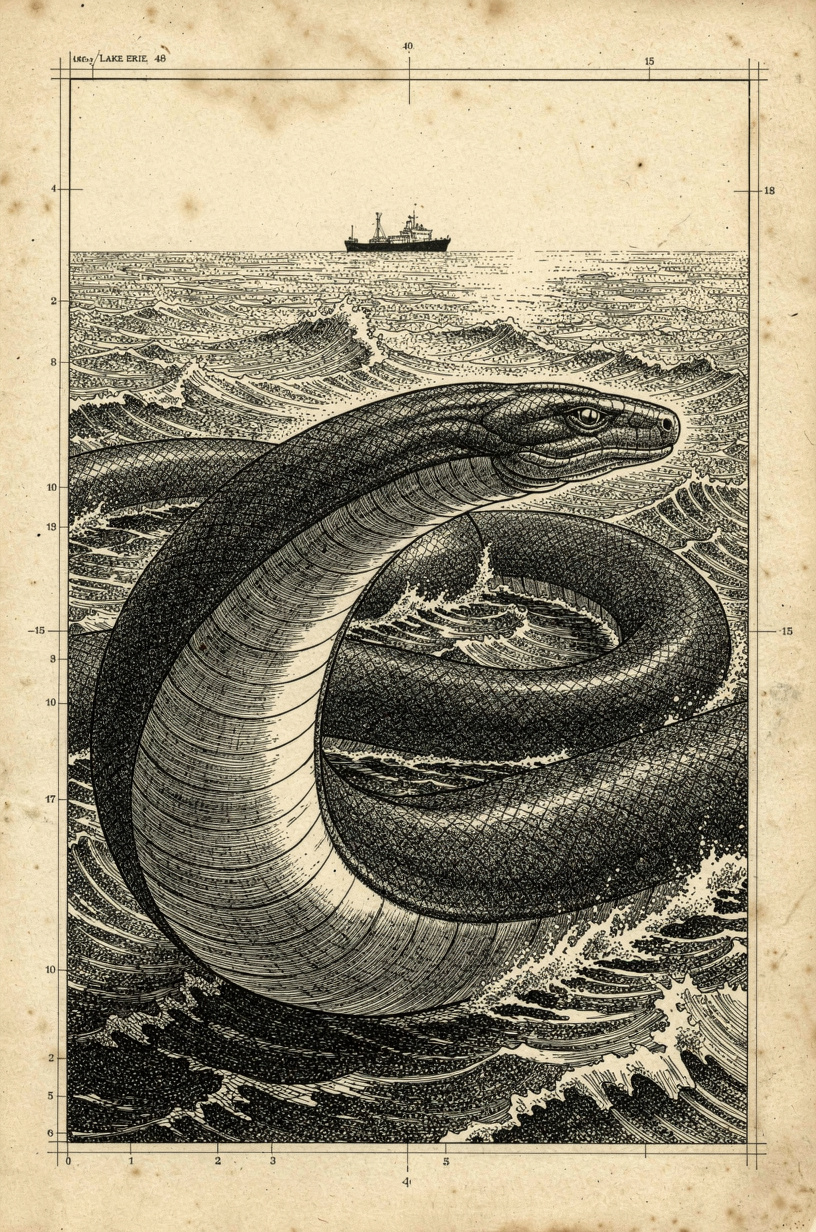
Lake Erie's serpentine resident. Documented since 1817. It is still there.
Lake Erie's serpentine entity has been documented continuously since 1817, when the crew of the schooner Felicity reported a large coiled serpent near Sandusky Bay, Ohio. In the 200 years since, the accounts have not stopped. "Bessie" — the name became standard in 20th-century media coverage — is described as 30–40 feet in length, dark gray to black in color, with a flat head and a serpentine body wide enough that witnesses compare it to a telephone pole in diameter. It has been sighted from shore, from boats, and from the Bass Islands that dot the Ohio side of the lake.
Erie is the shallowest of the Great Lakes — maximum depth 210 feet, average depth 62 — which makes it theoretically the most observable. The paradox is that its murky, nutrient-rich water provides substantially less visibility at depth than Superior. The lake's commercial shipping traffic, its charter fishing industry, and its dense recreational boating produce more human eyes per square mile of water surface than any other Great Lake. This means the Bessie account density is not an artifact of more observers — it represents a frequency of sightings proportional to exposure that is higher than would be expected for a simple misidentification pattern.
In 1992, the city of Sandusky offered a $100,000 reward for the live capture of the creature. No one collected. The same year, two independent sightings from separate locations — a fishing party near South Bass Island and a shore observer near Huron — were filed within three days of each other, describing the same entity in the same area. The reward has since been quietly removed from official city materials.
"We were anchored about a quarter mile off South Bass, and something surfaced about fifty yards off the port side. It wasn't a wave. The water was flat. It came up — three, maybe four feet of the back out of the water — and it moved parallel to us for maybe two minutes, then went under. It was dark, it was smooth, and it was longer than our boat. Our boat is thirty-two feet."— Filed with Ohio Division of Wildlife; charter captain with 18-year operating record; account not contested by reporting officer
- South Bay / South Bass Island, OHHighest frequency zone; namesake area
- Sandusky Bay, OH1817 initial account; ongoing
- Huron, OH shorelineShore-based sightings, recurrent
- Cedar Point area, OHMultiple boat-based accounts
The Loveland Frogman
Upright, four feet tall. Seen twice on the same Ohio bridge by separate officers.
The Loveland Frogman has one of the cleanest evidential records of any entity in this compendium: two separate law enforcement encounters, in the same location, by officers who did not know each other's accounts, within one year of each other. The location is a bridge over the Little Miami River near Loveland, Ohio, approximately 20 miles northeast of Cincinnati. The entity is described consistently in both accounts: bipedal, three to four feet tall, with smooth leathery skin, a distinctly frog-like facial structure, and eyes that reflected headlights in a way inconsistent with a human or known animal.
The first encounter: Officer Ray Shockey, January 1972. Driving near the Little Miami River bridge at 1am, he observed what he initially took to be a dog in the road. As he slowed, the figure stood upright, cleared the guardrail, and descended to the river. Shockey filed a report. The second encounter: Officer Mark Matthews, March 1972. Same road, same area. Matthews saw what he described as a large iguana-like creature on the road, which he struck with his cruiser and then observed closely before it climbed the embankment and disappeared. Matthews later amended his account in the 1990s to suggest it might have been an unusually large iguana with a missing tail. Shockey has never changed his account.
A third cluster of sightings occurred in 2016, when two teenagers reported a large frog-like creature standing upright near the Loveland Madeira Road bridge area — the same corridor. They photographed it. The photographs show a figure at the water's edge, upright, which the photographers identified as the Frogman. The photographs have not been definitively authenticated or debunked.
"I saw what I thought was a dog laying in the road. As I came up on it, it stood up on two legs. It was about three or four feet tall, and it had a face like a frog. It looked at me for a moment, then it went over the guardrail and down toward the river. I sat there for a minute trying to figure out what I had just seen. I got out and looked at the guardrail. There were scrape marks on it."— Officer Ray Shockey, Loveland Police Department, as recounted in multiple subsequent interviews; account maintained unchanged over 50 years

- Little Miami River bridge, Loveland1972 — both officer encounters
- Loveland Madeira Road bridge2016 — two civilian witnesses, photographs
- Little Miami River corridor1955 initial account — three entities observed
Beast of Bray Road
Wisconsin's wolf-man. First reported 1936. Still reported.
Bray Road is a rural road outside Elkhorn, Wisconsin, in Walworth County — a dairy farming landscape of fields, woodlots, and gravel roads. The entity that has used it as an apparent corridor since at least the 1930s is described by a remarkable consistency of witnesses across nine decades: large, powerfully built, covered in coarse dark-gray or black fur, with a distinctly canid head — elongated snout, upright ears, amber or golden eyes — capable of running on all fours but observed standing bipedally when observed at close range. It weighs, in witness estimates, somewhere between 400 and 700 pounds.
Investigative journalist Linda Godfrey broke the story for the Walworth County Week in 1991, after receiving reports from multiple independent witnesses who had not spoken to each other. The account density she documented — dairy farmer Lori Endrizzi, who saw the entity feeding on what appeared to be roadkill in 1989; Doris Gipson, whose car the entity struck in 1991; multiple other motorists on Bray Road over the same period — suggested a sustained presence rather than a single incident. Godfrey has since documented reports from across Wisconsin and Upper Michigan that describe the same entity over the same span of years.
The 1936 report — the earliest written account — comes from the caretaker of St. Coletta's School in Jefferson County, who described a large canine-faced creature walking upright on the school grounds. Whether this is the same entity as Bray Road's resident or a regional population is unresolved. The account density in Walworth County remains the highest. Whatever uses Bray Road uses it consistently enough that local residents no longer find the reports remarkable.
"It was kneeling at the edge of the road, kind of hunched over, eating something. I slowed down. When my headlights hit it, it looked up at me. The face was like a dog or a wolf — a long snout, pointed ears, and these light-colored eyes that just stared right at me. Then it stood up. I mean it stood up on its back legs. And I drove. I drove and I didn't stop for a very long time."— Lori Endrizzi; account filed with Linda Godfrey, 1991; consistent with descriptions from six other independent witnesses in the same county over the same period

- Bray Road, Elkhorn, WIPrimary corridor; 1989–present
- Walworth County road network9+ independent witnesses, same period
- Upper Michigan road corridorsRelated accounts, ongoing
- Jefferson County, WI1936 initial documented account
Mishipeshu
The Ojibwe Great Lynx. Guardian of copper and deep water. Not to be invoked.
Mishipeshu — the Great Lynx, the Underwater Panther — occupies a position in Anishinaabe cosmology that has no direct equivalent in the categories used by non-Indigenous researchers. It is not a cryptid in the sense that Bessie or the Frogman are cryptids. It is a being of the spirit world that manifests in the physical world, with specific locations, specific conditions under which it appears, and specific consequences for those who encounter it without preparation. It is the counterpart to the Thunderbird in the great opposition that structures Anishinaabe cosmology: sky against water, thunder against depths, the powers above against the powers below. The Great Lakes themselves are understood as Mishipeshu's domain.
The physical description — consistent across multiple Anishinaabe nations and encoded in the pictographs at Agawa Rock on the north shore of Lake Superior, painted before European contact — is specific: a large cat-like body with scales or copper-colored skin, horns on the head, a long and powerful tail used to generate whirlpools and dangerous currents, and a size that makes the creature capable of capsizing canoes. The copper association is significant: the Anishinaabe mined copper in the Lake Superior region for thousands of years, and Mishipeshu is described as the guardian of copper deposits in the lakebed, extractable only with proper ceremony and not to be taken without payment.
Canoeists and open-water paddlers who have ignored this tradition and crossed Lake Superior without ceremony have encountered conditions that experienced paddlers in known weather patterns cannot explain. Whether this is Mishipeshu, Lake Superior's meteorological volatility, or a category error in applying Western evidential standards to a spiritual tradition is not for this field guide to resolve. What is documented is that the tradition is specific, detailed, and has been continuous for a very long time in the exact territory where modern sightings of large aquatic entities in Lake Superior continue to be filed.
"The painting at Agawa shows Mishipeshu with clarity that suggests the artist was working from observation rather than description: the horns, the scaled body, the pronounced tail, the posture in water. It is accompanied by canoes — Ojibwe canoes — crossing the lake. The scale of Mishipeshu relative to the canoes is not figurative. It is literal. The being that was understood to inhabit this lake was understood to be very large."— Field notes, Lake Superior shoreline documentation project; Agawa Rock Provincial Park, Ontario

- Lake Superior (full extent)Primary domain; Agawa Rock documentation
- Lake Michigan northern watersAssociated Anishinaabe territory
- Pictured Rocks, MICopper-bearing shoreline zone
- Keweenaw Peninsula, MIHistorically significant copper territory
The Paulding Light
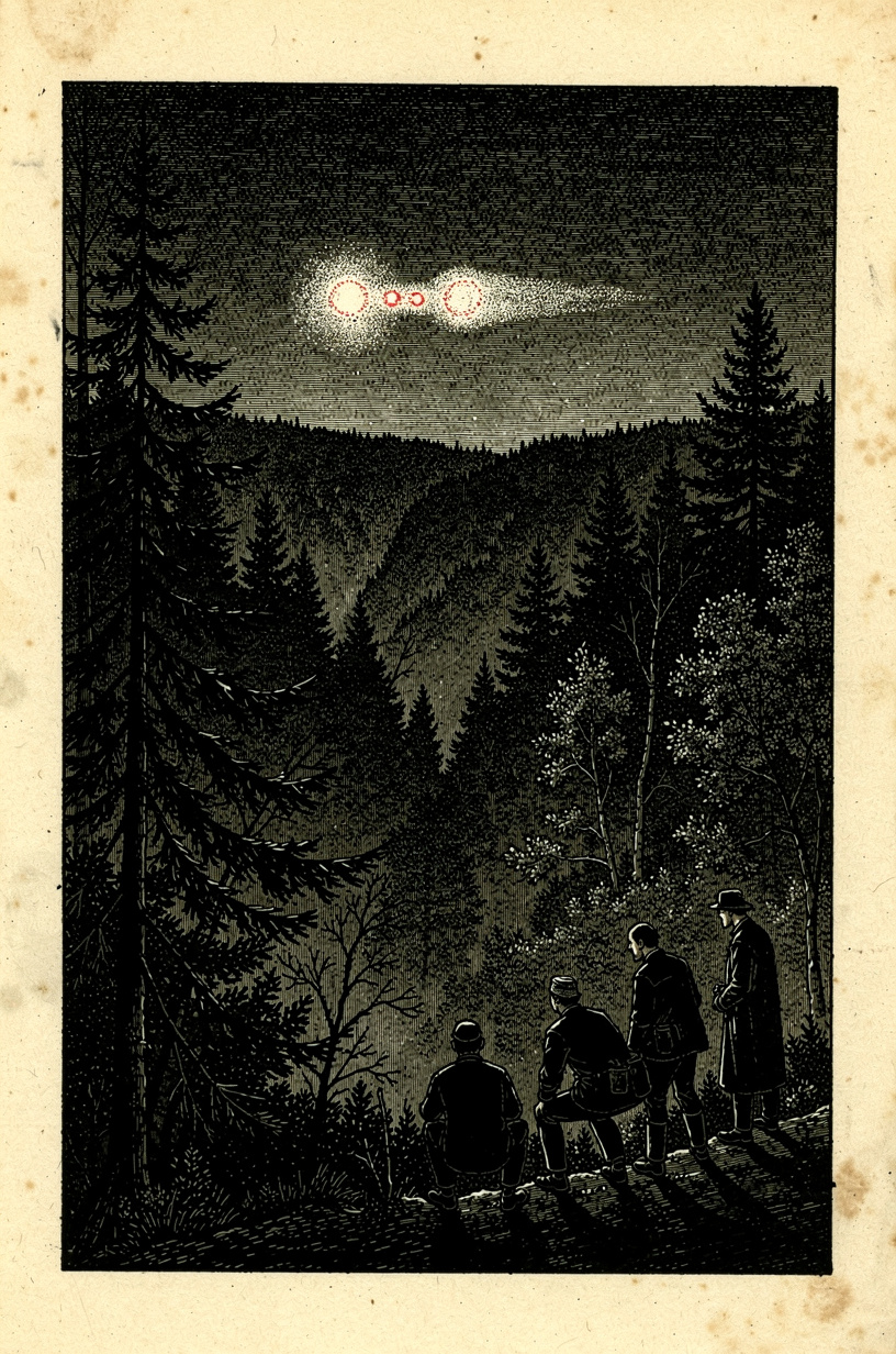
A light appears nightly over a Michigan valley. It has done so for over sixty years.
On US-45 south of Paulding in Michigan's Upper Peninsula, there is a gravel road pull-off with a Forest Service sign directing visitors to a specific spot from which a light — or lights — can be observed in a valley below. The light has appeared here, reliably, for over sixty years. It is white and red, it moves, it rises and descends, it sometimes splits, and it has been observed from this same location continuously since the mid-1960s by local residents, tourists, students, and researchers who cannot agree on what it is.
A 2010 investigation by a University of Michigan physics team concluded that the light is car headlights and taillights from US-45 several miles north — an optical illusion created by the terrain and refraction. This explanation has significant support in the research community. It is disputed by longtime observers who point out that the Paulding Light was documented before US-45 ran through that corridor, and that the light's behavior — particularly the splitting, color-changing, and hovering behavior on windless nights — does not match headlight patterns in a consistent way.
The local legend attached to the light predates the highway explanation: a railroad brakeman killed in the valley, swinging his lantern; the ghost of a Native American dancing in the clearing; an energy emanation from a ley line. These explanations are offered by the locals as alternatives, not as the researchers' working hypothesis. What is not in dispute is that something produces a consistent light effect in that valley every night, that it has done so for six decades, and that no explanation has yet satisfied all observers simultaneously.
"We stood at the observation area for two hours. The light appeared within fifteen minutes of full dark, as locals said it would. It was white at first, then shifted to red. It rose and fell in the valley. At one point it split into two distinct points and then rejoined. We had a compass that was behaving oddly. We had no explanation. We drove the highway to the north and looked back — I understand the theory, but what I saw did not move the way headlights on a curved road move. I am still not certain what I saw."— Submitted via Upper Peninsula Paranormal Research Association; independent researcher; first-person observation account
- US-45, south of Paulding, MIPrimary observation point; Forest Service sign
- Paulding valley, Ontonagon CountyLight's apparent location
Folkloric & Indigenous Record
Mishipeshu & the Anishinaabe Cosmos
In Anishinaabe cosmology, the world is governed by a fundamental tension between the powers of the sky — represented by the Thunderbird — and the powers of the water, represented by Mishipeshu and the underwater beings. This is not mythology in the dismissive sense; it is a cosmological model that encodes observed natural phenomena into a relational framework. Storms are produced by this tension. The Great Lakes are its primary arena. The Anishinaabe have lived on these shores for over a thousand years and have developed protocols — ceremony, specific crossing practices, offerings — for navigating a landscape they understood as inhabited by powerful non-human beings. Those protocols reflect accumulated observational knowledge.
Agawa Rock Pictographs
The pictographs at Agawa Rock, painted on a cliff face above Lake Superior's waterline on the Ontario north shore, include what is arguably the most detailed pre-contact depiction of Mishipeshu in existence. The paintings — accessible only by water, requiring a specific crossing of dangerous shoreline — show the Great Lynx in relation to canoes and to the open lake, with the entity's scale relative to the vessels depicted literally rather than symbolically. Researchers working on Great Lakes aquatic entity accounts return to Agawa Rock because the physical description encoded in paintings made centuries ago matches the physical descriptions in contemporary filed reports with a specificity that demands explanation.
Beast of Bray Road in Wisconsin Oral Tradition
Linda Godfrey, the journalist who broke the Beast of Bray Road story in 1991, has documented that local knowledge of the entity preceded her investigation by decades. Rural Walworth County families with deep roots in the area described an entity called the "Bray Road Monster" or simply "the thing on the road" in terms consistent with post-1991 accounts, without prompting. The oral tradition of agricultural communities in this region does not typically produce cryptid lore as a category; the consistent reference to a specific, large, canid-faced biped by multiple unconnected farming families over a sixty-year period is not typical folklore behavior. It suggests repeated contact with an observed entity.
Great Lakes Sea Serpent Traditions
Aquatic serpentine entities are documented in the oral traditions of peoples indigenous to every one of the five Great Lakes. The names and specific attributes vary, but the core description — a large serpentine being inhabiting the deep lake, surfacing rarely, associated with dangerous water conditions — is present in Ojibwe, Potawatomi, and Erie-adjacent traditions before European contact. When European settlers arrived and began filing accounts of sea serpents in the same lakes, they were not describing new phenomena. They were adding written accounts to an oral archive that already had centuries of documentation. The tradition and the modern report database describe the same entities in the same waters.
Filed Accounts
"It surfaced fifty yards off. Thirty-two feet of serpent moving parallel to my boat for two minutes."
Charter captain with 18-year operating record on Lake Erie files account following a July 1992 encounter off South Bass Island. Entity surfaced and maintained parallel course before submerging without turbulence. Account not contested by the receiving officer. Captain has continued operating the same route for thirty years.
"It looked at me. Then it stood up. Then it went over the guardrail. I sat there for a long time."
Officer Ray Shockey's January 1972 account of the Loveland Frogman — filed the same week, details maintained unchanged over five decades. The guardrail scrape marks he reported were subsequently confirmed by a second officer who inspected the site. Officer Matthews's 1972 account corroborated the location and physical description while diverging on interpretation.
"It was feeding on the roadside. When my lights hit it, it stood up and looked directly at my car."
Doris Gipson's 1991 Bray Road account — her car struck the entity as it crouched in the road. She describes it standing to examine her vehicle before retreating. Her account was independently corroborated by dairy farmer Lori Endrizzi and four other witnesses over the same period, none of whom had spoken to each other before going to journalist Linda Godfrey.
"I was kayaking Lake Superior. The water changed. Something was underneath my boat. I have not gone back."
Solo paddler on Lake Superior's north shore reports a sudden calm followed by a deep movement beneath the kayak — not current, not swell. Visual of a dark mass at depth, estimated fifteen feet below the hull and substantially larger than the vessel. The paddler made shore. The water behind them showed surface disruption for several minutes after landing.
"The light split into two, held for thirty seconds, then rejoined. Every compass in the group was off by twenty degrees."
Four-person research team at the Paulding Light observation area documents the light over two hours. Records the splitting behavior, color transition from white to red, and compass anomalies during the light's peak activity period. Drove the US-45 corridor afterward and found that replicating the light's behavior with vehicle headlights required conditions that were not present on the observation night.
"My grandmother said don't cross Lake Superior without asking permission first. I thought she was speaking metaphorically."
A paddler of Anishinaabe heritage recounts attempting a Lake Superior crossing without ceremony, at the advice of their non-Indigenous expedition partner. They describe a sequence of water conditions the partner — an experienced open-water kayaker — described as unlike anything they had seen in twenty years: localized, personal, following the boats rather than moving with the weather. They completed the crossing. The partner has not returned to Superior.
Open Water Protocol
Do not kayak or canoe Lake Superior alone, and do not cross the open lake — the Pictured Rocks to Keweenaw corridor in particular — without proper preparation. If you are of Anishinaabe heritage or have access to ceremony, this is the appropriate preparation. If you are not, study the meteorology thoroughly and do not underestimate the speed at which conditions change. Aquatic entity encounters are statistically rare. Superior drownings are not.
Rural Road Encounters
Bray Road and related Walworth County corridors are most active between 10pm and 2am. If you encounter a large canid-faced entity on a rural road, do not approach. Do not exit your vehicle. Note the location, time, weather, and your distance estimate. The entity in these accounts has shown no aggression except in the single case where a vehicle made contact. It appears to be using the roads as transit corridors, not hunting in them.
Mishipeshu and the Deep Water
Mishipeshu is not a cryptid to be observed, documented, and filed. It is a being of significant power in an active spiritual tradition held by the Anishinaabe peoples of the Great Lakes region. If you are on Lake Superior and something happens to the water that you cannot explain — localized conditions, something at depth, a sudden calm followed by turbulence — what you do next is your decision. What we document is that the people who have lived on these shores longest have protocols for this situation. Those protocols exist for a reason.